Thursday

Concept of Region in Geography


Concept of Region in Geography


In geography, regions are the areas that are broadly divided by its physical characteristics (physical geography), human impact characteristics (human geography), and the interaction of humanity and the environment (environmental geography).


 Geographic regions and sub-regions are mostly described by their imprecisely defined, and sometimes transitory boundaries, except in human geography, where jurisdiction areas such as national borders are defined in law.


 In the 20th century regions were classified into different categories ( different functional regions or planning regions) with the help of different statistical methods showing functional homogeneity in multiple attributes  At present, the Region and regionalization get wide spectrum through the planning process in any country or a state or small unit of a natural, functional, or vernacular region of the word; to achieve the goal of sustainable development.


Characteristics of Region

 A region is an area of a specific location.  Distinctiveness: Every region is a distinct geographical area;  Uniqueness  Homogeneity: Homogeneity in one ore more geographical element within the boundary;  Heterogeneity: Heterogeneity in those elements towards its regional boundaries;  Dynamic/ Changing character: A region has dynamic character because its features where change during times; whether it is physical or human elements, single or multiple feature elements or functional or planning regions; geographical features where dynamics;  Hierarchy: Every region has some kind of hierarchical arrangement.  Dynamic Scale: A region can be different in scale according to its shape and size.  Problematic: Every region have similar problems within its boundary;  Purposive: A region is delineated for specific proposes.  Resourceful: A region should be resourceful or have some specific resources so that they were utilized in the planning process.


Structure of Region

Node  Zone  Area


Node – Here polarization or centralization of Phenomenon is found. Nodes develop in functional regions but unidentified in formal regions.


Zone – it is segment of space/part of an area where intensity and magnitude of phenomenon is maximum.


Area– It include Node + Zone + Transitional Boundaries.


Thus Region is Node + Zone + Transitional Boundaries.


The three main types of regions are 

formal, 

functional, and

perceptional/vernacular regions.


Formal (Uniform) region


A formal region is a geographical region that is homogeneous and uniform within a specified criterion. This specified criterion could be physical, social, or political. Example – Himalayan Region, Sub-Tropical Region, etc. Such regions may be referred to as natural regions as they exist naturally on the geographical space.  It is an area in which everyone shares in common one or more distinctive characteristics. This common characteristic could be a cultural value such as language, an economic activity such as the production of a certain crop, or an environmental property such as climate and weather patterns. Whatever the common characteristic is, it is present throughout the selected region.  In certain formal regions, the characteristic may be predominant rather than universal, such as the wheat belt in North America, it is an area in which the predominant crop is wheat, but other crops are grown here as well.  It's is further divided in 'Single feature Region '(ex. Physiographic regions of India),"Multiple Feature region' (ex. Resource Region or Planning region), and 'Compage region' (ex. Agricultural region of the World).  Whittlessy (1956) defined 'compage region' as a uniform region where all the features of the physical, biotic and social environment are functionally associated with the human occupance.  Later there was a shift to the use of economic criteria and social and political criteria such as language, religion, tribal population, political allegiance etc. Economic formal regions were initially based on types of industry or agriculture, but the scope of economic regionalisation expanded to the use of other criteria like income level, rate of unemployment and rate of economic growth. An important change in the scheme of regionalisation was an increasing emphasis on multiple criteria regionalisation rather than single criterion regionalisation. This indicated the increasing awareness of the thinkers and planners about the complexity that exists in the human world and the need for a logical categorisation of the complexity that exists over space. The world has been divided into a number of natural regions such as equatorial, temperate, tundra, desert, savannah regions etc. based on the climate, natural vegetation and location.


Types of Regions (Classification of Regions)


 Regions are classified on the basis of selected criteria and purpose or goal.  Primarily they are classified as  Naïve region: It is a mental construct/ idealistic and hypothetical and subjective in nature (e. backward region).  Instituted region  Denoted region or Planning region  Several geographers have worked on the typology of regions. Typology approach is also known as classical approach divides the region into Single aspect region  Multiple aspect region  Regions of totality  Functional regions  Regions can also be classified as  Regions based on the physical character  Regions based on cultural character  Regions based on an amalgamation of physical and cultural variables  Regions can also be classified on the basis of scale for Multi-Level Planning  Macro-Macro level for studying a whole nation or state  Macro-level for studying states within a nation  Meso level for studying districts  Micro-level for studying city/village  Micro minor level for studying a particular sector or household  Based on Areal homogeneity regions can be classified into  Physical region: It includes land, soil, climate, vegetation, etc. For example Tropical region, Savanna region, Black soil region, Downs, etc.  Economic region: It includes industrial regions, agricultural regions, services, etc., for example, Special Economic Zones, Great North Indian Plains.  Cultural region: the demarcation of the cultural region is based on language, religion, etc. For example Hindi heartland, tribal regions, etc  Campage Regions with more than one feature showing areal homogeneity. The above regions were demarcated based on a single feature but in Campage more than one features are selected.  Based on Areal Linkages regions can be classified into  Nodal region: Here there is one dominant urban centre around which smaller urban/rural areas develop.  Axial region: It is the region that develops along a corridor and performs a special function. E. DMIC along National Highway 8  Adhoc region: they are transitional regions not on a permanent basis, and are generally backward regions. Here planning is done with a specific purpose in order to develop the particular region.  Now a day a more comprehensive approach is followed for better planning and development.


Naïve regions

 These are largely mental constructs and they are perceived section of space  These have ill-defined boundaries or transitional zone or no boundaries.  The criteria selected for demarcation are abstract and such regions are more fanciful.  Such regions don't have a well-structured association of region-building elements and they are vaguely identified.  An example of the above is the cultural region because culture can't be defined in precise terms and within a cultural region, elements of culture have contradictions like marriage rituals vary within the culture.  The regions get their name by people living outside the region e. Mithila, Avadh, etc.  These naïve regions are further classified as  Metaphysical region: They don't exist in reality and more based on philosophy. E. concept of heaven/hell, the Marxist idea of the utopian society.  World/physical regions: They are identifiable, observable but can never be confined within a lined boundary. They are largely transitional. E. cultural region Mithila, Avadh, etc.


 The criteria may be physical. E. (topography climate, vegetation) or economic like industrial or agricultural (income, rate of unemployment, rate of economic growth) or cultural (language, central India tribal belt)  They are largely fixed and static.  They are identifiable by their composition or assemblage of the phenomenon.  Example –  Natural regions like Savanna, rain forest.  Linguistic regions  The bioclimatic region, Physiographic region, economic region, hydrological region  Functional region:  It is a geographical area that displays a certain functional coherence i. interdependence of parts.  It is composed of heterogeneous units such as towns, cities, and villages which are functionally interrelated and working as a system  The relationships are usually studied in form of flow (functional flow between towns and villages). For e. journey to work trips or shopping trips, the flow of goods and services, communication, etc.  Thus, they have flow patterns (flow of goods and services from village to towns) and development of nodes (city and village acts as nodes of flow).  The criteria taken for the identification of functional region is objective and identifiable e. Industrial region, Metropolitan region, Tourism region, Administrative region, Political region, tribal area development, etc.  Nodal region comprises of the node or core or hub which connects all activities and unifies the region e. Mumbai is a node and the sprawling region have interdependency to the node.  They are suitable for designing and implementing development plans for dealing with regional plans, for dealing with regional problems such as metropolitan or city region, river valley region, axial region (DMIC), transitional/depressed region (e. KalahandiBolangir- Koraput (KBK) region).  According to C. Pathak and Amitabh Kundu, a planning region should have the following characteristics:  It should be large enough to contain a range of resources, conditions, and attributes so as to serve the desired degree of economic viability and at the same time not too large to make a comprehensive approach too general (should not lose its uniqueness).  It should have a fairly homogeneous economic structure as well as topographical and socio-cultural homogeneity (e. KBK region).  A balance is needed between homogeneity, nodality, and administrative convergence while delimiting a region.  Planning regions should be internally cohesive.  Resource should be such that a satisfactory level of product combination for consumption and exchange is feasible.  It should have few nodal points, to regulate geographically contiguous areal units (e. KBK region of Orissa).  Planning Regions are generally arranged in hierarchical patterns such as Macro, Meso, Micro, etc. Here the bottom-up approach is followed for planning purposes (e. village to block to district).


Wednesday

Spatial filtering, Remote Sensing. Low-pass filter. High-pass filter

Spatial filtering encompasses another set of digital processing functions which are used to enhance the appearance of an image. Spatial filters are designed to highlight or suppress specific features in an image based on their spatial frequency. Spatial frequency is related to the concept of image texture.


It refers to the frequency of the variations in tone that appear in an image. "Rough" textured areas of an image, where the changes in tone are abrupt over a small area, have high spatial frequencies, while "smooth" areas with little variation in tone over several pixels, have low spatial frequencies. A common filtering procedure involves moving a 'window' of a few pixels in dimension (e.g. 3x3, 5x5, etc.) over each pixel in the image, applying a mathematical calculation using the pixel values under that window, and replacing the central pixel with the new value. The window is moved along in both the row and column dimensions one pixel at a time and the calculation is repeated until the entire image has been filtered and a "new" image has been generated. By varying the calculation performed and the weightings of the individual pixels in the filter window, filters can be designed to enhance or suppress different types of features.


Low-pass filter

A low-pass filter is designed to emphasize larger, homogeneous areas of similar tone and reduce the smaller detail in an image. Thus, low-pass filters generally serve to smooth the appearance of an image. Average and median filters, often used for radar imagery are examples of low-pass filters.


High-pass filters do the opposite and serve to sharpen the appearance of fine detail in an image. One implementation of a high-pass filter first applies a low-pass filter to an image and then subtracts the result from the original, leaving behind only the high spatial frequency information. Directional, or edge detection filters are designed to highlight linear features, such as roads or field boundaries. These filters can also be designed to enhance features which are oriented in specific directions. These filters are useful in applications such as geology, for the detection of linear geologic structures.


Tuesday

Grey level thresholding. Level slicing. Contrast stretching lo p

Grey level thresholding.

Level slicing.

Contrast stretching.


Image enhancement


Lillesand and Kiefer (1994) explained the goal of image enhancement procedures is to improve the visual interpretability of any image by increasing the apparent distinction between the features in the scene. This objective is to create "new" image from the original image in order to increase the amount of information that can be visually interpreted from the data.


Enhancement operations are normally applied to image data after the appropriate restoration procedures have been performed. Noise removal, in particular, is an important precursor to most enhancements. In this study, typical image enhancement techniques are as follows:


Grey level thresholding


Grey level thresholding is a simple lookup table, which partitions the gray levels in an image into one or two categories - those below a user-selected threshold and those above. Thresholding is one of many methods for creating a binary mask for an image. Such masks are used to restrict subsequent processing to a particular region within an image.


This procedure is used to segment an input image into two classes: one for those pixels having values below an analyst- defined gray level and one for those above this value. (Lillesand and Kiefer, 1994).


Level slicing


Level slicing is an enhancement technique whereby the Digital Numbers (DN) distributed along the x-axis of an image histogram is divided into a series of analyst-specified intervals of "slices". All of DNs falling within a given interval in the input image are then displayed at a single DN in the output image (Lillesand and Kiefer, 1994).


Contrast stretching


Most satellites and airborne sensor were designed to accommodate a wide range of illumination conditions, from poorly lit arctic regions to high reflectance desert regions. Because of this, the pixel values in the majority of digital scenes occupy a relatively small portion of the possible range of image values. If the pixel values are displayed in their original form, only a small range of gray values will be used, resulting in a low contrast display on which similar features night is indistinguishable.


A contrast stretch enhancement expands the range of pixel values so that they are displayed over a fuller range of gray values. (PCI, 1997)


Generally, image display and recording devices typically operate over a range of 256 gray levels (the maximum number represent in 8-bit computer encoding). In the case of 8-bit single image, is to expand the narrow range of brightness values typically present in an output image over a wider range of gray value. The result is an output image that is designed to accentuate the contrast between features of interest to the image analyst (Lillesand and Kiefer, 1994).

The grey level or grey value indicates the brightness of a pixel. The minimum grey level is 0. The maximum grey level depends on the digitisation depth of the image. For an 8-bit-deep image it is 255. In a binary image a pixel can only take on either the value 0 or the value 255.


Monday

Aquifer. Types of Aquifer.


What is an Aquifer?


An aquifer is a body of saturated rock through which water can easily move. Aquifers must be both permeable and porous and include such rock types as sandstone, conglomerate, fractured limestone and unconsolidated sand and gravel. Fractured volcanic rocks such as columnar basalts also make good aquifers. The rubble zones between volcanic flows are generally both porous and permeable and make excellent aquifers. In order for a well to be productive, it must be drilled into an aquifer. Rocks such as granite and schist are generally poor aquifers because they have a very low porosity. However, if these rocks are highly fractured, they make good aquifers. A well is a hole drilled into the ground to penetrate an aquifer. Normally such water must be pumped to the surface. If water is pumped from a well faster than it is replenished, the water table is lowered and the well may go dry. When water is pumped from a well, the water table is generally lowered into a cone of depression at the well. Groundwater normally flows down the slope of the water table towards the well. 

Is an Aquifer an Underground River?
No. Almost all aquifers are not rivers. Since water moves slowly through pore spaces in an aquifer's rock or sediment, the only life-forms that could enjoy floating such a 'river' would be bacteria or viruses which are small enough to fit through the pore spaces. True underground rivers are found only in cavernous rock formations where the rock surrounding cracks or fractures has been dissolved away to leave open channels through which water can move very rapidly, like a river.

Ground water has to squeeze through pore spaces of rock and sediment to move through an aquifer (the porosity of such aquifers make them good filters for natural purification. Because it takes effort to force water through tiny pores, ground water loses energy as it flows, leading to a decrease in hydraulic head in the direction of flow. Larger pore spaces usually have higher permeability, produce less energy loss, and therefore allow water to move more rapidly. For this reason, ground water can move rapidly over large distances in aquifers whose pore spaces are large (like the lower Portneuf River aquifer) or where porosity arises from interconnected fractures. Ground water moves very rapidly in fractured rock aquifers like the basalts of the eastern Snake River Plain. In such cases, the spread of contaminants can be difficult or impossible to prevent.

What does an aquifer look like?
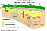
Every aquifer is unique, although some are more generic than others. The boundaries of an aquifer are usually gradational into other aquifers, so that an aquifer can be part of an aquifer system. The top of an unconfined aquifer is the water table. A confined aquifer has at least one aquitard at its top and, if it is stacked with others, an aquitard at its base.

Click for larger view.
figure 1. Click on image for larger view.

Figure 1 shows an example of an aquifer system in the lower Portneuf River valley. The diagram represents a cut-away perspective view of this system of multiple aquifers and is greatly exaggerated in its vertical scale to show some of the details. Several different aquifers occur in this valley. In the northern valley (beneath Chubbuck and north Pocatello) multiple confined aquifers are stacked on top of one another and separated by aquitards made of clay; the aquifers tapped by Chubbuck's municipal wells are in the fractured basalts of the eastern Snake River Plain. In the southern valley (Portneuf Gap to Red Hill) the upper surface of the unconfined aquifer is the water table.

How Does an Aquifer Work?
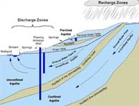
An aquifer is filled with moving water and the amount of water in storage in the aquifer can vary from season to season and year to year. Ground water may flow through an aquifer at a rate of 50 feet per year or 50 inches per century, depending on the permeability. But no matter how fast or slow, water will eventually discharge or leave an aquifer and must be replaced by new water to replenish or recharge the aquifer. Thus, every aquifer has a recharge zone or zones and a discharge zone or zones.

Click for larger view.
figure 2. Click on image for larger view.

Figure 2 is a simple cartoon showing three different types of aquifers: confined, unconfined, and perched. Recharge zones are typically at higher altitudes but can occur wherever water enters an aquifer, such as from rain, snowmelt, river and reservoir leakage, or from irrigation. Discharge zones can occur anywhere; in the diagram, discharge occurs not only in springs near the stream and in wetlands at low altitude, and also from wells and high-altitude springs.

The amount of water in storage in an aquifer is reflected in the elevation of its water table. If the rate of recharge is less than the natural discharge rate plus well production, the water table will decline and the aquifer's storage will decrease. A perched aquifer's water table is usually highly sensitive to the amount of seasonal recharge so a perched aquifer typically can go dry in summers or during drought years.

Why is Groundwater So Clean?
Aquifers are natural filters that trap sediment and other particles (like bacteria) and provide natural purification of the ground water flowing through them.

Like a coffee filter, the pore spaces in an aquifer's rock or sediment purify ground water of particulate matter (the 'coffee grounds') but not of dissolved substances (the 'coffee'). Also, like any filter, if the pore sizes are too large, particles like bacteria can get through. This can be a problem in aquifers in fractured rock (like the Snake River Plain, or areas outside the sediment-filled valleys of southeast Idaho).

Clay particles and other mineral surfaces in an aquifer also can trap dissolved substances or at least slow them down so they don't move as fast as water percolating through the aquifer.

Natural filtration in soils is very important in recharge areas and in irrigated areas above unconfined aquifers, where water applied at the surface can percolate through the soil to the water table. For example, in the lower Portneuf River valley (Figure 1), a protective layer of silt in the southern valley provides natural protection to the aquifer from septic systems, pesticide application, and accidental chemical spills.

Despite natural purification, concentrations of some elements in ground water can be high in instances where the rocks and minerals of an aquifer contribute high concentrations of certain elements. In some cases, such as iron staining, health impacts due to high concentrations of dissolved iron are not a problem as much as the aesthetic quality of the drinking water supply. In other cases, where elements such as fluoride, uranium, or arsenic occur naturally in high concentrations, human health may be affected.

How is an Aquifer Contaminated?
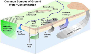
As shown in Figure 3, an aquifer can be contaminated by many things we do at and near the surface of the earth. Contaminants reach the water table by any natural or manmade pathway along which water can flow from the surface to the aquifer.

Deliberate disposal of waste at point sources such as landfills, septic tanks, injection wells and storm drain wells can have an impact on the quality of ground water in an aquifer.

Click for larger view.
figure 3. Click on image for larger view.

In general, any activity which creates a pathway that speeds the rate at which water can move from the surface to the water table has an impact. In , waste water leaking down the casing of a poorly constructed well bypasses the natural purification afforded by soil. Excessive addition of fertilizer, agrichemicals, and road de-icing chemicals over broad areas, coupled with the enhanced recharge from crops, golf courses and other irrigated land and along road ditches, are common reasons for contamination arising from non-point sources. Removal of soil in excavations and mining reduces the purification potential and also enhances recharge; in some cases, such as the Highway Pond gravel pits south of Pocatello, the water table is exposed and becomes directly vulnerable to the entry of contaminated.


Folding. Geomorphology. Geography.

Folding. Geomorphology. Geography.