Tuesday

Grey level thresholding. Level slicing. Contrast stretching lo p

Grey level thresholding.

Level slicing.

Contrast stretching.


Image enhancement


Lillesand and Kiefer (1994) explained the goal of image enhancement procedures is to improve the visual interpretability of any image by increasing the apparent distinction between the features in the scene. This objective is to create "new" image from the original image in order to increase the amount of information that can be visually interpreted from the data.


Enhancement operations are normally applied to image data after the appropriate restoration procedures have been performed. Noise removal, in particular, is an important precursor to most enhancements. In this study, typical image enhancement techniques are as follows:


Grey level thresholding


Grey level thresholding is a simple lookup table, which partitions the gray levels in an image into one or two categories - those below a user-selected threshold and those above. Thresholding is one of many methods for creating a binary mask for an image. Such masks are used to restrict subsequent processing to a particular region within an image.


This procedure is used to segment an input image into two classes: one for those pixels having values below an analyst- defined gray level and one for those above this value. (Lillesand and Kiefer, 1994).


Level slicing


Level slicing is an enhancement technique whereby the Digital Numbers (DN) distributed along the x-axis of an image histogram is divided into a series of analyst-specified intervals of "slices". All of DNs falling within a given interval in the input image are then displayed at a single DN in the output image (Lillesand and Kiefer, 1994).


Contrast stretching


Most satellites and airborne sensor were designed to accommodate a wide range of illumination conditions, from poorly lit arctic regions to high reflectance desert regions. Because of this, the pixel values in the majority of digital scenes occupy a relatively small portion of the possible range of image values. If the pixel values are displayed in their original form, only a small range of gray values will be used, resulting in a low contrast display on which similar features night is indistinguishable.


A contrast stretch enhancement expands the range of pixel values so that they are displayed over a fuller range of gray values. (PCI, 1997)


Generally, image display and recording devices typically operate over a range of 256 gray levels (the maximum number represent in 8-bit computer encoding). In the case of 8-bit single image, is to expand the narrow range of brightness values typically present in an output image over a wider range of gray value. The result is an output image that is designed to accentuate the contrast between features of interest to the image analyst (Lillesand and Kiefer, 1994).

The grey level or grey value indicates the brightness of a pixel. The minimum grey level is 0. The maximum grey level depends on the digitisation depth of the image. For an 8-bit-deep image it is 255. In a binary image a pixel can only take on either the value 0 or the value 255.


Monday

Aquifer. Types of Aquifer.


What is an Aquifer?


An aquifer is a body of saturated rock through which water can easily move. Aquifers must be both permeable and porous and include such rock types as sandstone, conglomerate, fractured limestone and unconsolidated sand and gravel. Fractured volcanic rocks such as columnar basalts also make good aquifers. The rubble zones between volcanic flows are generally both porous and permeable and make excellent aquifers. In order for a well to be productive, it must be drilled into an aquifer. Rocks such as granite and schist are generally poor aquifers because they have a very low porosity. However, if these rocks are highly fractured, they make good aquifers. A well is a hole drilled into the ground to penetrate an aquifer. Normally such water must be pumped to the surface. If water is pumped from a well faster than it is replenished, the water table is lowered and the well may go dry. When water is pumped from a well, the water table is generally lowered into a cone of depression at the well. Groundwater normally flows down the slope of the water table towards the well. 

Is an Aquifer an Underground River?
No. Almost all aquifers are not rivers. Since water moves slowly through pore spaces in an aquifer's rock or sediment, the only life-forms that could enjoy floating such a 'river' would be bacteria or viruses which are small enough to fit through the pore spaces. True underground rivers are found only in cavernous rock formations where the rock surrounding cracks or fractures has been dissolved away to leave open channels through which water can move very rapidly, like a river.

Ground water has to squeeze through pore spaces of rock and sediment to move through an aquifer (the porosity of such aquifers make them good filters for natural purification. Because it takes effort to force water through tiny pores, ground water loses energy as it flows, leading to a decrease in hydraulic head in the direction of flow. Larger pore spaces usually have higher permeability, produce less energy loss, and therefore allow water to move more rapidly. For this reason, ground water can move rapidly over large distances in aquifers whose pore spaces are large (like the lower Portneuf River aquifer) or where porosity arises from interconnected fractures. Ground water moves very rapidly in fractured rock aquifers like the basalts of the eastern Snake River Plain. In such cases, the spread of contaminants can be difficult or impossible to prevent.

What does an aquifer look like?
Every aquifer is unique, although some are more generic than others. The boundaries of an aquifer are usually gradational into other aquifers, so that an aquifer can be part of an aquifer system. The top of an unconfined aquifer is the water table. A confined aquifer has at least one aquitard at its top and, if it is stacked with others, an aquitard at its base.
Click for larger view.
figure 1. Click on image for larger view.

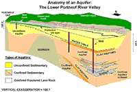
Figure 1 shows an example of an aquifer system in the lower Portneuf River valley. The diagram represents a cut-away perspective view of this system of multiple aquifers and is greatly exaggerated in its vertical scale to show some of the details. Several different aquifers occur in this valley. In the northern valley (beneath Chubbuck and north Pocatello) multiple confined aquifers are stacked on top of one another and separated by aquitards made of clay; the aquifers tapped by Chubbuck's municipal wells are in the fractured basalts of the eastern Snake River Plain. In the southern valley (Portneuf Gap to Red Hill) the upper surface of the unconfined aquifer is the water table.

How Does an Aquifer Work?
An aquifer is filled with moving water and the amount of water in storage in the aquifer can vary from season to season and year to year. Ground water may flow through an aquifer at a rate of 50 feet per year or 50 inches per century, depending on the permeability. But no matter how fast or slow, water will eventually discharge or leave an aquifer and must be replaced by new water to replenish or recharge the aquifer. Thus, every aquifer has a recharge zone or zones and a discharge zone or zones.
Click for larger view.
figure 2. Click on image for larger view.

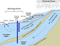
Figure 2 is a simple cartoon showing three different types of aquifers: confined, unconfined, and perched. Recharge zones are typically at higher altitudes but can occur wherever water enters an aquifer, such as from rain, snowmelt, river and reservoir leakage, or from irrigation. Discharge zones can occur anywhere; in the diagram, discharge occurs not only in springs near the stream and in wetlands at low altitude, and also from wells and high-altitude springs.

The amount of water in storage in an aquifer is reflected in the elevation of its water table. If the rate of recharge is less than the natural discharge rate plus well production, the water table will decline and the aquifer's storage will decrease. A perched aquifer's water table is usually highly sensitive to the amount of seasonal recharge so a perched aquifer typically can go dry in summers or during drought years.

Why is Groundwater So Clean?
Aquifers are natural filters that trap sediment and other particles (like bacteria) and provide natural purification of the ground water flowing through them.

Like a coffee filter, the pore spaces in an aquifer's rock or sediment purify ground water of particulate matter (the 'coffee grounds') but not of dissolved substances (the 'coffee'). Also, like any filter, if the pore sizes are too large, particles like bacteria can get through. This can be a problem in aquifers in fractured rock (like the Snake River Plain, or areas outside the sediment-filled valleys of southeast Idaho).

Clay particles and other mineral surfaces in an aquifer also can trap dissolved substances or at least slow them down so they don't move as fast as water percolating through the aquifer.

Natural filtration in soils is very important in recharge areas and in irrigated areas above unconfined aquifers, where water applied at the surface can percolate through the soil to the water table. For example, in the lower Portneuf River valley (Figure 1), a protective layer of silt in the southern valley provides natural protection to the aquifer from septic systems, pesticide application, and accidental chemical spills.

Despite natural purification, concentrations of some elements in ground water can be high in instances where the rocks and minerals of an aquifer contribute high concentrations of certain elements. In some cases, such as iron staining, health impacts due to high concentrations of dissolved iron are not a problem as much as the aesthetic quality of the drinking water supply. In other cases, where elements such as fluoride, uranium, or arsenic occur naturally in high concentrations, human health may be affected.

How is an Aquifer Contaminated?
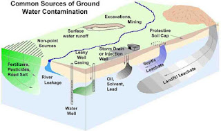
As shown in Figure 3, an aquifer can be contaminated by many things we do at and near the surface of the earth. Contaminants reach the water table by any natural or manmade pathway along which water can flow from the surface to the aquifer.

Deliberate disposal of waste at point sources such as landfills, septic tanks, injection wells and storm drain wells can have an impact on the quality of ground water in an aquifer.
Click for larger view.
figure 3. Click on image for larger view.

In general, any activity which creates a pathway that speeds the rate at which water can move from the surface to the water table has an impact. In , waste water leaking down the casing of a poorly constructed well bypasses the natural purification afforded by soil. Excessive addition of fertilizer, agrichemicals, and road de-icing chemicals over broad areas, coupled with the enhanced recharge from crops, golf courses and other irrigated land and along road ditches, are common reasons for contamination arising from non-point sources. Removal of soil in excavations and mining reduces the purification potential and also enhances recharge; in some cases, such as the Highway Pond gravel pits south of Pocatello, the water table is exposed and becomes directly vulnerable to the entry of contaminated.


Aquifer. Types of Aquifer.

What is an Aquifer?


An aquifer is a body of saturated rock through which water can easily move. Aquifers must be both permeable and porous and include such rock types as sandstone, conglomerate, fractured limestone and unconsolidated sand and gravel. Fractured volcanic rocks such as columnar basalts also make good aquifers. The rubble zones between volcanic flows are generally both porous and permeable and make excellent aquifers. In order for a well to be productive, it must be drilled into an aquifer. Rocks such as granite and schist are generally poor aquifers because they have a very low porosity. However, if these rocks are highly fractured, they make good aquifers. A well is a hole drilled into the ground to penetrate an aquifer. Normally such water must be pumped to the surface. If water is pumped from a well faster than it is replenished, the water table is lowered and the well may go dry. When water is pumped from a well, the water table is generally lowered into a cone of depression at the well. Groundwater normally flows down the slope of the water table towards the well. 

Is an Aquifer an Underground River?
No. Almost all aquifers are not rivers. Since water moves slowly through pore spaces in an aquifer's rock or sediment, the only life-forms that could enjoy floating such a 'river' would be bacteria or viruses which are small enough to fit through the pore spaces. True underground rivers are found only in cavernous rock formations where the rock surrounding cracks or fractures has been dissolved away to leave open channels through which water can move very rapidly, like a river.

Ground water has to squeeze through pore spaces of rock and sediment to move through an aquifer (the porosity of such aquifers make them good filters for natural purification. Because it takes effort to force water through tiny pores, ground water loses energy as it flows, leading to a decrease in hydraulic head in the direction of flow. Larger pore spaces usually have higher permeability, produce less energy loss, and therefore allow water to move more rapidly. For this reason, ground water can move rapidly over large distances in aquifers whose pore spaces are large (like the lower Portneuf River aquifer) or where porosity arises from interconnected fractures. Ground water moves very rapidly in fractured rock aquifers like the basalts of the eastern Snake River Plain. In such cases, the spread of contaminants can be difficult or impossible to prevent.

What does an aquifer look like?
Every aquifer is unique, although some are more generic than others. The boundaries of an aquifer are usually gradational into other aquifers, so that an aquifer can be part of an aquifer system. The top of an unconfined aquifer is the water table. A confined aquifer has at least one aquitard at its top and, if it is stacked with others, an aquitard at its base.

Click for larger view.
figure 1. Click on image for larger view.

Figure 1 shows an example of an aquifer system in the lower Portneuf River valley. The diagram represents a cut-away perspective view of this system of multiple aquifers and is greatly exaggerated in its vertical scale to show some of the details. Several different aquifers occur in this valley. In the northern valley (beneath Chubbuck and north Pocatello) multiple confined aquifers are stacked on top of one another and separated by aquitards made of clay; the aquifers tapped by Chubbuck's municipal wells are in the fractured basalts of the eastern Snake River Plain. In the southern valley (Portneuf Gap to Red Hill) the upper surface of the unconfined aquifer is the water table.

How Does an Aquifer Work?
An aquifer is filled with moving water and the amount of water in storage in the aquifer can vary from season to season and year to year. Ground water may flow through an aquifer at a rate of 50 feet per year or 50 inches per century, depending on the permeability. But no matter how fast or slow, water will eventually discharge or leave an aquifer and must be replaced by new water to replenish or recharge the aquifer. Thus, every aquifer has a recharge zone or zones and a discharge zone or zones.

Click for larger view.
figure 2. Click on image for larger view.

Figure 2 is a simple cartoon showing three different types of aquifers: confined, unconfined, and perched. Recharge zones are typically at higher altitudes but can occur wherever water enters an aquifer, such as from rain, snowmelt, river and reservoir leakage, or from irrigation. Discharge zones can occur anywhere; in the diagram, discharge occurs not only in springs near the stream and in wetlands at low altitude, and also from wells and high-altitude springs.

The amount of water in storage in an aquifer is reflected in the elevation of its water table. If the rate of recharge is less than the natural discharge rate plus well production, the water table will decline and the aquifer's storage will decrease. A perched aquifer's water table is usually highly sensitive to the amount of seasonal recharge so a perched aquifer typically can go dry in summers or during drought years.

Why is Groundwater So Clean?
Aquifers are natural filters that trap sediment and other particles (like bacteria) and provide natural purification of the ground water flowing through them.

Like a coffee filter, the pore spaces in an aquifer's rock or sediment purify ground water of particulate matter (the 'coffee grounds') but not of dissolved substances (the 'coffee'). Also, like any filter, if the pore sizes are too large, particles like bacteria can get through. This can be a problem in aquifers in fractured rock (like the Snake River Plain, or areas outside the sediment-filled valleys of southeast Idaho).

Clay particles and other mineral surfaces in an aquifer also can trap dissolved substances or at least slow them down so they don't move as fast as water percolating through the aquifer.

Natural filtration in soils is very important in recharge areas and in irrigated areas above unconfined aquifers, where water applied at the surface can percolate through the soil to the water table. For example, in the lower Portneuf River valley (Figure 1), a protective layer of silt in the southern valley provides natural protection to the aquifer from septic systems, pesticide application, and accidental chemical spills.

Despite natural purification, concentrations of some elements in ground water can be high in instances where the rocks and minerals of an aquifer contribute high concentrations of certain elements. In some cases, such as iron staining, health impacts due to high concentrations of dissolved iron are not a problem as much as the aesthetic quality of the drinking water supply. In other cases, where elements such as fluoride, uranium, or arsenic occur naturally in high concentrations, human health may be affected.

How is an Aquifer Contaminated?
As shown in Figure 3, an aquifer can be contaminated by many things we do at and near the surface of the earth. Contaminants reach the water table by any natural or manmade pathway along which water can flow from the surface to the aquifer.

Deliberate disposal of waste at point sources such as landfills, septic tanks, injection wells and storm drain wells can have an impact on the quality of ground water in an aquifer.

Click for larger view.
figure 3. Click on image for larger view.

In general, any activity which creates a pathway that speeds the rate at which water can move from the surface to the water table has an impact. In Figure 3, waste water leaking down the casing of a poorly constructed well bypasses the natural purification afforded by soil. Excessive addition of fertilizer, agrichemicals, and road de-icing chemicals over broad areas, coupled with the enhanced recharge from crops, golf courses and other irrigated land and along road ditches, are common reasons for contamination arising from non-point sources. Removal of soil in excavations and mining reduces the purification potential and also enhances recharge; in some cases, such as the Highway Pond gravel pits south of Pocatello, the water table is exposed and becomes directly vulnerable to the entry of contaminated.


Wednesday

Remote Sensing Multi & Hyperspectral Systems


<iframe style='width:900px;height:500px' src='https://online.pubhtml5.com/fjpl/pxsm/'  seamless='seamless' scrolling='no' frameborder='0' allowtransparency='true' allowfullscreen='true' ></iframe>


Satellite Remote Sensing; Multispectral imaging; Using Discrete Detectors and Scanning mirrors- Landsat- MMS, TM, ETM+; NOAA- GOES, NOAA-AVHRR; SeaWiFS Multispectral imaging Using Linear Arrays; SPOT 1, 2, 3 HRV, SPOT 4, 5 HRVIR; IRS- LISS III and LISS IV; ASTER; Quick Bird Imaging Spectrometry using Linear and Area Arrays; AVIRIS, MODIS 


Vineesh V
AISHE and UGC Nodal Officer
Assistant Professor of Geography,
Government College Chittur, Palakkad

https://vineesh-geography.business.site

Folding. Geomorphology. Geography.

Folding. Geomorphology. Geography.